This page requires some cookies for the shop functionality, but there are also cookie, that are only used for marketing. Please accept the use of cookies. For more information, look at Privacy Policy
- Stocktrek Images
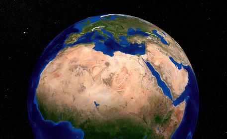
- Earth showing North Africa.
„Earth showing North Africa.“
from the gallery of
Stocktrek Images
Description:
The Blue Marble Next Generation data set provides a monthly global cloud-free true-color picture of the Earth's landcover at a 500-meter spatial resolution. This data set, shown on a globe, is derived from monthly data collected in 2004. This image shows the three regions in North Africa: The Sahara, the Sahel, and the Sudan. The Sahel is a semi-arid belt of barren, sandy and rock-strewn land which stretches 3,860km across the breadth of the African continent and marks the physical and cultural divide between the continentâ€TMs more fertile south (the Sudan Region) and Saharan desert north.
Picture ID:
12086c0
Related Tags:
- adriatic sea
- aegean sea
- africa
- algeria
- aral sea
- asia
- balearic sea
- baltic
- black sea
- circle
- color image
- countries
- desert
- earth
- egypt
- europe
- france
- geography
- global
- globe
- greece
- gulf
- horizontal
- ionian sea
- iran
- iraq
- island
- italy
- landmass
- landscape
- libya
- ligurian sea
- mediterranean
- morocco
- no people
- outdoors
- peninsula
- photography
- planet
- red sea
- regions
- round
- russia
- sahara
- sahel
- saudi arabia
- sea
- single object
- space
- spain
- sudan
- topography
- tyrrhenian sea
- world
- terra
- blue planet
- landform
- land feature
- arid climate
- middle east
- caspian sea
- mediterranean sea
- map
- arabian peninsula
- arabia
- continent
- circles
- worldwide
- golf
- dry climate
- blueplanet
- near east
- country-functional
- balearic-sea
- landforms
Style:


There are no comments yet, be the first!